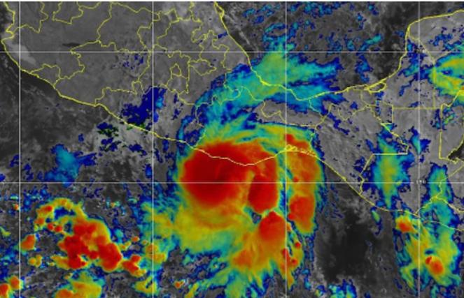
Agatha: the first Category 2 Hurricane for the month of May in Mexico; will move towards the Gulf of Mexico next days

Hurricane Agatha, the first named storm of the year in the East Pacific Ocean, was borned on 25th of May on the East Pacific Ocean southwest of Mexico. It's the second hurricane that has the same name and made a landfall over Mexico. Agatha is already spreading heavy thunderstorms across the southern parts of Mexico and could continue its course across the Gulf of Mexico on Friday.
4pm CDT 30 May - #Hurricane #Agatha has made landfall just west of Puerto Angel, Mexico, with maximum sustained winds of 105 mph.
— NHC Eastern Pacific (@NHC_Pacific) May 30, 2022
Since record keeping began in 1949, this is the strongest hurricane to make landfall in May along the Pacific coast of Mexico. pic.twitter.com/dUraseRoDe
Agatha, the first Category 2 Hurricane for the month of May in Mexico: Agatha began as a tropical disturbance and it involved and intensified to a Tropical Storm on 28th of May, while on 29th of may became a Category 1 Hurricane and later that day a Category 2 Hurricane as it reached sustainable winds of 175km/h with a pressure of 970hPa. Hurricane Agatha continued its eastwards course towards Mexico, bringing upheaval to the citizens of Mexico and Guatemala. On Monday afternoon Hurricane Agatha made a landfall on the southern Mexico coast when it was still a Category 2 Hurricane. Hurricane Agatha had maximum sustained winds around 165-170 km/h on Monday, slightly close to being a Category 3 Hurricane (178-207km/h). It was the first Category 2 Hurricane for the month of May that made landfall on Mexico! Previous 2 hurricanes that were recorded were Category 1 Hurricanes and were named Barbara (May 29, 2013) and Agatha (May 24, 1971).
Agatha could cause flooding next days across southern Mexico: when Agatha moved inland, today on 31th of May, it rapidly lost its power and wind intensity and was downgraded to a Category 1 hurricane, while later to a tropical storm with maximum sustained winds close to 110 km/h. Large strong waves and strong onshore winds caused large water accumulation. Agatha continues to lose wind intensity, but it is still a great danger as it can cause flash flooding. As Agatha is moving east towards the Gulf of Mexico will bring the next hours onland strong thunderstorms to the southern parts of Mexico. On Wednesday it will be centered over Villahermosa, reaching Bay of Campeche. Next 3 days big accumulations rates are expected across southern Mexico with maximum values reaching 150-200mm, while it could also reach 250-350mm locally across the southeastern parts of Mexico, for example over Quintana Roo. Rain totals over the mountain will be higher than 300mm.
Agatha could move across the Gulf of Mexico: the remnants of Agatha are expected to head towards the Caribbean Sea and many scenarios show that Agatha could intensify when it reaches the warm waters of Gulf of Mexico. On Friday as Agatha will start crossing the Gulf it could become stronger and it seems that it will continue a northeastern course making landfall over Cuba, the Bahamas and Florida spreading powerful thunderstorms accompanied by strong winds. New scenarios show that Agatha could continue its course across to the Atlantic Ocean next week, which is rare as only 5 tropical systems had passed from the Pacific to the Atlantic Ocean. More rare is for a tropical system to pass from the Pacific to the Atlantic than the opposite. The latest cross from one basin to another was Otto in November 2016.
