TYPHOON RAI in PHILIPPINES: damaging winds, flash floods and severe thunderstorms
WEATHER FORECASTING FOR THE TYPHOON RAI

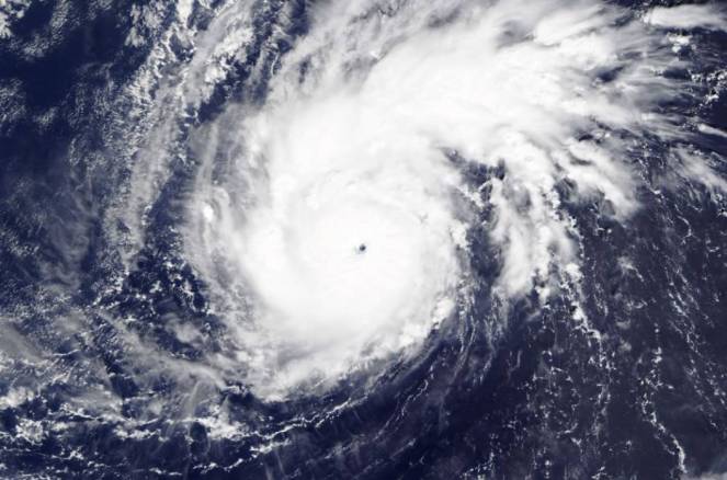
Typhoon Rai is located in the Philippine Sea and is moving westwards towards the Philippines with maximum sustainable winds of 150 km/h and pressure 977 mbars. Rai started as a tropical depression on Monday 13 of December, but quickly became a tropical storm with maximum sustainable winds of 65-90 km/h the same day. Tuesday was categorised as a Severe Tropical Storm in strength as the maximum sustainable winds were 100-110 km/h with pressure at 990 mbars.
Typhoon #Rai (#OdettePH) is approaching the #Philippines. It will make landfall over #Surigao in around 12 hours, then track right across the archipelago with winds up to 140 km/h.
— Zoom Earth (@zoom_earth) December 15, 2021
Follow LIVE: https://t.co/eOIQXlcvi5 pic.twitter.com/yQJwGUCNQ6
BUT WHAT ARE THE REASONS OF TYPHOON RAI'S INTENSIFICATION? Not only the sea waters that Rai is travelling through are really warm with temperatures near 29C, but also there is a lack of strong vertical wind shear, supporting the system and helping it to maintain its warm core that fuels all tropical systems. Vertical wind shear of less than 10 m/s between the ocean surface and the tropopause is required for tropical cyclone development.
TYPHOON RAI WILL BECOME CATEGORY 2 HURRICANE. The Typhoon in the Philippines is well known as Odette because of different naming conventions. Typhoon Rai is expected to intensify and become a Category 2 Hurricane on the Saffir-Simpson Hurricane Wind Scale (maximum sustained winds 96-110 mph or 154-177 km/h). In the Philippines, national authorities have started with preparedness and response measures, ahead of the arrival of RAI.

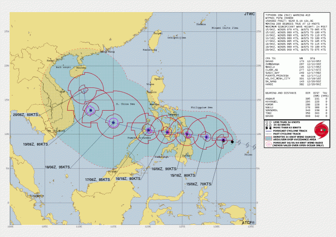
DAMAGING WINDS AND SEVERE FLASH FLOODS ON THURSDAY. According to the latest forecasting data, Typhoon Rai will hit eastern Philippines on Thursday morning with sustainable winds of 156km/h. The strong winds will be accompanied by severe embedded thunderstorms, causing flash floods, which will be more intense across central and southern Philippines. The citizens must be alert for severe weather phenomena that can cause rivers to quickly rise and flood low-lying roads. The damaging winds could topple trees onto roadways, create power outages or roofs destruction. As the day passes the Typhoon will slightly ease, with sustainable winds reaching 140 km/h at 12:00 in Bohol.
FRIDAY RAI WILL MOVE TOWARDS PUERTO PRINCESA, BECOMING STRONGER. On Friday morning Rai will leave the central Philippines, with sustainable winds of 130 km/h, losing a little bit of its strength as it has crossed the land. It will continue its northwestern course travelling towards northern Puerto Princesa, gaining strength from the warm Sulu Sea with maximum sustainable winds of 145-152 km/h. The severe thunderstorms will continue spreading high amounts of rain, turning more heavy over Taytay and Dumaran.
VERY HIGH RAIN TOTALS. Rain totals from Thursday to Saturday can reach 100-250 mm in many regions of Philippines, while locally in central and southern areas can exceed 400mm.
OUTLOOK. Saturday morning will be west of Puerto Princesa moving northwestwards towards the South China Sea with maximum sustainable winds of 166-176 km/h. The Typhoon will continue spreading showers or thunderstorms over the Philippines. Sunday it will continue its course towards Vietnam with maximum winds of 136-141km/h while its strength will start easing as it moves towards Hainan on Monday degrading to a Tropical Storm.
