Weather Europe: cold temperatures, frost and snow
It has been 131 years since Northern Sweden had such cold November!.
ore 19:21
Redazione 3BMeteo
2 minuti, 41 secondi

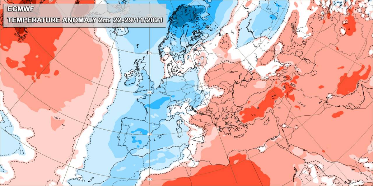
IT HAS BEEN 131 YEARS SINCE NORTHERN SWEDEN HAD SUCH COLD NOVEMBER! COLDER THAN USUAL IN NORTHERN SCANDINAVIA. The last few days, colder air masses than normal have settled in Scandinavia bringing severe frost and heavy snow. Specifically, on Wednesday 24/11/2021 the minimum temperature was -32.2℃ in Kevo, northern Finland, which was the lowest temperature ever recorded for November in Finland since 2010, when the mercury fell to -34℃ at the same weather station. While the temperature continued to drop, on the 28th of november a new record was set at -37C in Nattavaara of Lapland (327 meters) and at -37.4C in Nikkaluokta, northern Sweden. Other stations recorded similar values, with -36°C in Arrenjarka and -35°C in Karesuando. It has not been that cold since 1890 when the Swedish national monthly record for November was set at -43°C. In the photo below you can observe the intense anomaly of temperature at 2m from 22 to 29 of November.

WILL COLD TEMPERATURES CONTINUE TO PERSIST IN NORTHERN SCANDINAVIA? The next couple of days will be warmer in northern Scandinavia, but this weekend we expect to see very cold temperatures, as arctic air masses will rule. The coldest temperatures in winter vary between -45°C and -50°C in Lapland and between -35°C and -45°C for eastern Finland.
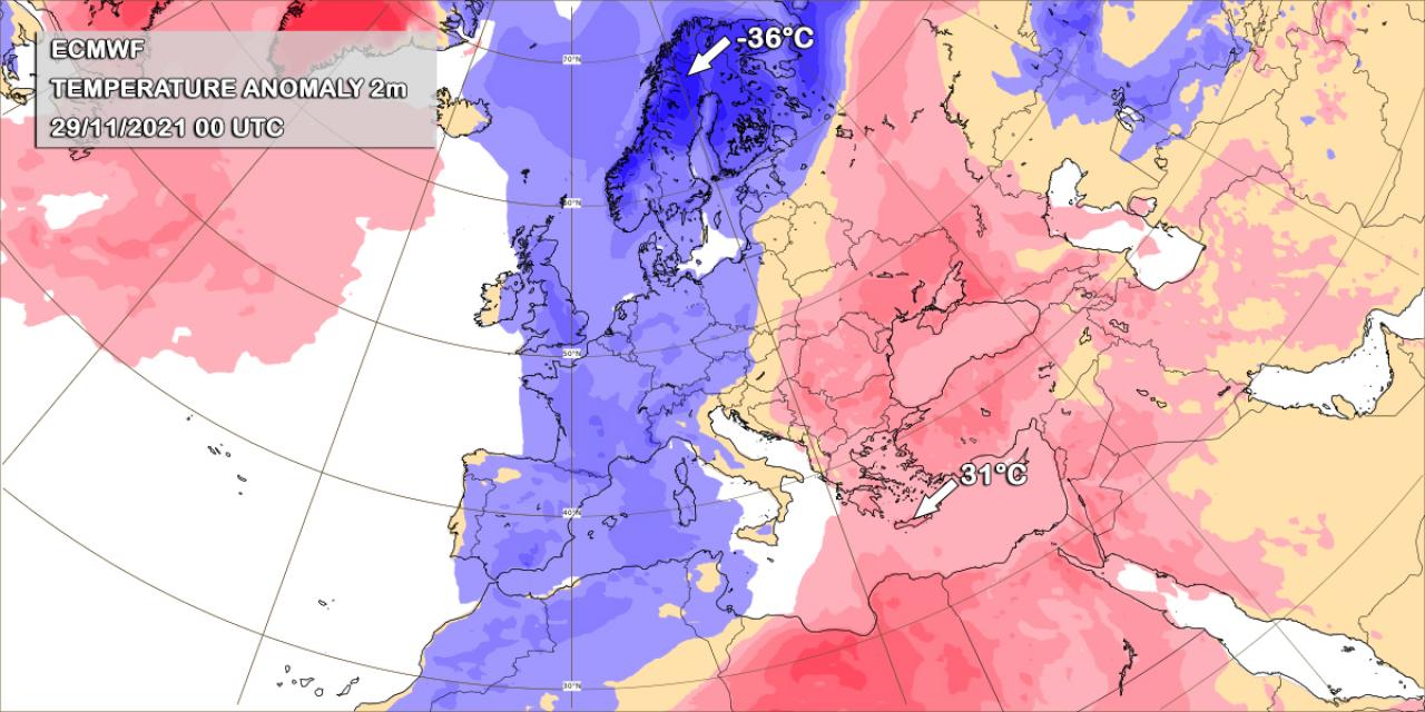
67°C TEMPERATURE DIFFERENCE BETWEEN NORTHERN AND SOUTHERN EUROPE. A big difference in temperature was observed on Monday 29/11/2021 between northern Sweden and southern Greece. Early Monday morning the temperature in northern Sweden was -36°C while in Crete, southern Greece was 31°C (according to the weather stations of National Observatory of Athens), resulting in a difference of 67°C! This interesting difference in temperature is due to the strong jet stream which carried cold arctic air masses towards central and northern Europe, while really warm air masses were moved over southeastern Europe.

OUTLOOK. COLD TEMPERATURES, FROST AND SNOW. As low pressure systems continue to dominate the central and northern Europe will bring new bands of rain which will be wintry in places, turning to heavy snow in places over Denmark, southern Sweden, eastern Poland, the Alps, the Baltic states and Belarus. These severe weather conditions will be accompanied by cold winds, which will be stronger in the British Isles, the Northern Sea, the Bay of Biscay and western France, Denmark and the Baltic Sea with wind gusts reaching locally 80-100 km/h. As the strong jetstream dips down once again it will bring several shots of arctic air to central and northern Europe spreading cold and frost. On Thursday temperature drop is expected in central Europe with maximum temperatures varying between 2 and 5°C, while in northeastern Europe will vary between -5 to 3°C. On Friday, the maximum temperature is expected between 0-4°C in central Europe, while northeastern Europe is expecting a total frost in most of the cities with the maximum temperature varying between -6 to 0°C.
AUTHOR: EFTHYMIA DINOPOULOU
