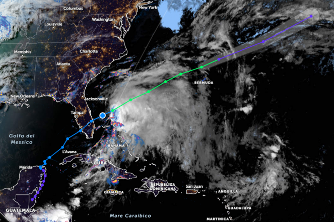
Tropical System Alex: severe floods across the Caribbean Islands and Florida; the remnants of Alex will head towards the UK on Friday

Alex borned from the remnants of Agatha, a powerful Category 2 Hurricane which made a landfall over Mexico last week, and traveled across the Caribbean Islands and Florida the last few days bringing severe flooding. Alex is a tropical cyclone today over Bermuda and will downgrade into an extratropical Cyclone later today. Alex will continue traveling across the North Atlantic Ocean and will reach between Thursday and Friday the UK. It's really rare for a tropical system to be alive and travel these long distances as Alex does.
The first organized tropical storm for the Atlantic Ocean, Alex, formed in the Gulf of Mexico from the remnants of Hurricane Agatha, a Pacific storm that landed into Mexico as a Category 2 storm spreading severe thunderstorms and damaging winds across the southern regions. The storm killed at least nine people as it moved over Mexico and into the Gulf. Alex, from Friday until Sunday, passed through the Caribbean Islands spreading severe thunderstorms, resulting in severe flooding. Florida was also affected by the Alex, mostly during Sunday, as it was strengthened into a tropical storm, with sustainable winds reaching 100km/h, leading locally close to accumulations of 300 mm or more across the southern parts. For example, Hollywood (Florida), reached nearly 381 mm of rain in 48 hours with similar accumulation rates in Margate and Biscayne Park. Alex also caused many flights to be canceled or delayed last Saturday.
It doesn't look like Florida has the resiliency it will need for climate change yet.https://t.co/44BHLL9sHB
— Daniel Chomsky (@DanielChomsky) June 4, 2022
2am EDT 5 June -- Satellite imagery & @53rdWRS aircraft data indicates that former Potential Tropical Cyclone One (#PTC1) has developed a well-defined center & has become Tropical Storm #Alex.
— National Hurricane Center (@NHC_Atlantic) June 5, 2022
Maximum sustained winds has increased to 50 mph.
Latest: https://t.co/B1w22rbdGC pic.twitter.com/0qbSq7kaTJ
Today, Alex is a tropical storm that passes through Bermuda bringing severe thunderstorms accompanied by strong winds resulting in coastal flooding as the wave height reaches even 6-7m! Maximum sustained winds are close to 100 km/h with higher gusts. During the next few hours Alex will weaken, becoming an extratropical low.
Next days Alex will continue its northeastern course towards the North Atlantic Ocean as an extratropical cyclone, but will no longer be a danger as it will travel across the Ocean. The latest forecasting data reveals that the remnants of Alex will continue heading northeastwards, centered on Thursday west of Ireland, bringing strong winds and rain by the end of the week to the UK turning heavy across western Ireland and Scotland. The southwestern winds could bring coastal flooding through Thursday and Friday across the western and southern regions of Ireland, while on Friday and Saturday to western Scotland. Wind gusts could reach 100km/h, while waves will reach 6-7m west of Ireland.
